
Bury Meadow
Page updated 10th June 2017
 This little park is situated on
the road to St
David's Station and North Devon. According to Alexander Jenkins, the name derives from 'Berry Mead'
which probably itself, comes from burh or earthwork as the Danes Castle
siege earthworks are close by. Sir Edward Seaward, Mayor in 1691, was a principal benefactor of Berry (Bury) Meadow by donating four-fifths of the land, and Margery Gould providing the remainder to the City Chamber. Rental from the land went towards supporting the Exeter Workhouse.
This little park is situated on
the road to St
David's Station and North Devon. According to Alexander Jenkins, the name derives from 'Berry Mead'
which probably itself, comes from burh or earthwork as the Danes Castle
siege earthworks are close by. Sir Edward Seaward, Mayor in 1691, was a principal benefactor of Berry (Bury) Meadow by donating four-fifths of the land, and Margery Gould providing the remainder to the City Chamber. Rental from the land went towards supporting the Exeter Workhouse.
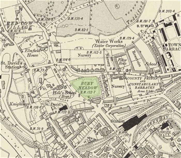
The cholera plot
A plot 92 ft by 109 ft was excavated as a burying ground for victims of the 1832 cholera outbreak. It was 440 ft from St David's Church and was adjacent to Barrack Road (now Howell Road). The map shows the position of the burial ground. It also shows how Bury Meadow stretched from St David's Church to Barrack Road (now Howell Road). Heles School, Heles Road, New North Road, Elmfield Road and Richmond Road have not yet been built.
Shapter wrote in his book, The History of the Cholera in Exeter:
The Board of Health ... resolved,—" that the North-west corner of Little Bury Meadow be forthwith appropriated for a burial-ground for persons dying of Cholera ; and that a sum of money not exceeding £200 be placed at the disposal of this body for purchasing a piece of ground for the burial of persons dying of Cholera, if a more desirable situation than Bury Meadow can be found."
Despite the misgivings of the locals, who thought other burial grounds, elsewhere in the city should be opened, one hundred and fifty nine were interred in Bury Meadow and thirteen in a field in Pester Lane (off Union Road near Sylvan Road). The burial ground was reopened in 1833 and 1834 when cholera returned to city. In 1833, there were twenty additional burials and in 1834, fourteen burials.
The field becomes a park
The Commissioners of Improvement agreed in April 1845 to lease about four acres of Little Bury Meadow as a Public Promenade and Play Ground for the citizens, which along with Northernhay, formed the first of Exeter's many green spaces. It was named Victoria Park on the 1850 map by Warren, and a later 1881 map, but by 1888 it was back to Bury Meadow. In a true Victorian way, a tree was planted in the park to commemorate the marriage of HRH the Duke of Edinburgh KGL on 23 January 1874. Thus, what were important events at the time are lost in the memory of later generations.
The Coronation of Edward VII in 1901 saw Bury Meadow host sports for the Citizens' Treat day on 24th June. The schools attending were the Episcopal, St David's, Hoopern Street Girls, St Mary Arches Street Girls, St Sidwells, St James and St John's Hospital School. The Post Office Band was also in attendance to entertain the children. To round off the event, a Daylight Firework display was given.
Exeter's first historical pageant took place at Bury Meadow on 6 October 1909. Entitled, 'Briton and Roman', three hundred men and one hundred women enacted a clash between the Britons of Exeter, and the invading Romans. Personel from the Rovers Tourers, Willeys and Exeter Cycling Club took part, while the Higher Barracks supplied twenty men. A battering ram, and a section of the city and palisades were constructed by the Devon Fortress Engineers.
The blitz
In the days after the blitz of 4th May 1942, Bury Meadow was used for a field kitchen to feed women and children.
The park was used for the Exeter Annual Flower Show before it merged with the Devon County Flower Show at the Devon Show. Now, it
is a pleasant
green space in the city and has a small, well equipped children's
playground. It is well used by students from Exeter College, and is
even
used as an area to teach surveying. The Meadow is still occasionally
used for large gatherings and was the venue for a rally against the
Poll Tax in 1990.
A stone plaque in the park reads:
A GOOD LIFE IS A GARDEN WHICH YIELDS ITS CHOICEST COLOURS AT NOON AND ITS CHOICEST FRAGRANCE IN THE EVENING - FROM OLD ST PAULS EXON
Sources: History, Gazetteer and directory of Devonshire by WIlliam White, The History of the Cholera in Exeter in 1832 by Thomas Shapter, Flying Post and Express & Echo.

Map made for Thomas Shapter's, The History of the Cholera in Exeter in 1832. It shows the position of the cholera burial ground.

Edwardian postcard of Bury Meadow.
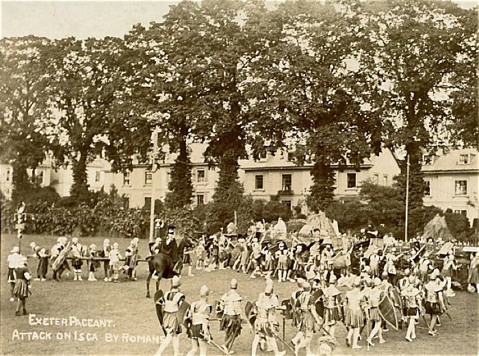
Romans marching across Bury Meadow in a pageant on 6 October 1909.
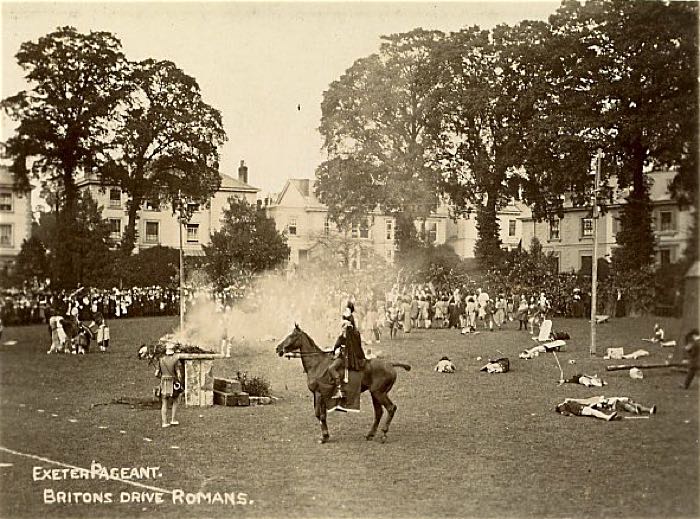
A horse gallops across a battleground during the pageant.
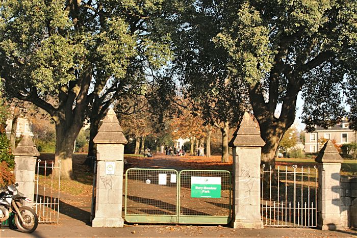
The main gate into Bury Meadow from New North Road.
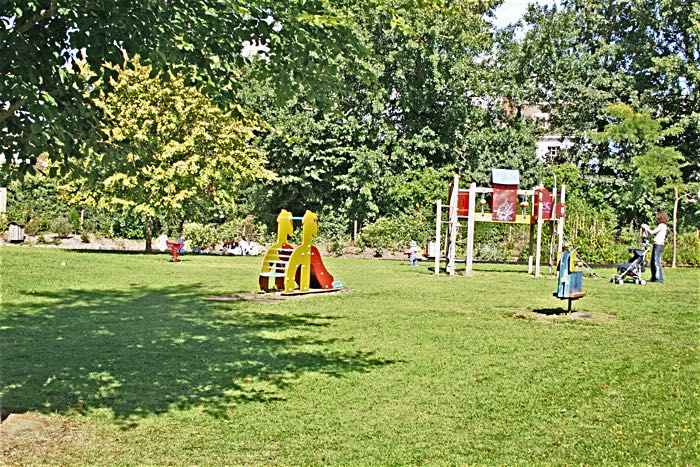
Under the children's playground is the cholera burial pit.
│ Top of Page │