- Home
- Memories
- Scrapbook ▽
- Topics ▽
- People ▽
- Events
- Photos
- Site Map
- Timeline
Latest update 19th September 2007
 The
part of Exeter known as the West Quarter was an important area in the
development of the city, and is an area to which many Exonians can
trace their roots.
An area bounded by Fore Street, South Street and the southern wall became an area for merchants, inns and industry to inhabit. Many merchants and priests lived in Preston Street, while the more successful a merchant became, the closer they lived to the Carfax, at the top of Fore Street and Mary Arches Street. Traders, artisans and labourers including the fullers, dyers and weavers that serviced the woollen industry lived in the lower parts of the West Quarter.
However, it would be wrong to suggest that the whole of the West Quarter consisted of merchants houses, workers hovels and industry. Rack Street is so named because it was used as a tenterground for hanging the processed woollen cloth to dry on racks spread across the open ground.
There were established several important inns within the West Quarter in the 16th century, including the Mermaid, White Hart and Dolphin. They would accommodate travellers to the city, along with their pack animals, and were important centres for trade. They became terminals for the many carriers in operation during the 18th and 19th centuries. The Dolphin Inn belonged to the Courtenay's or the Guild of Merchant Venturers and was mentioned in a document as early as 1578. The inn provided a carrier service on a Wednesday and Saturday to Ashburton and a Saturday service to Bath.
The area supported foundries and smithey working, and Robert Newton ran a bell foundry in Mermaid Yard in 1423, just to the west of Coombe Street. Bells from his foundry still ring from churches around Devon and Exeter, including St Pancras. Further over at the top of Smythen Street could be found Butchers Row, nineteen butchers shops, built by the City Chamber in 1499 and 1500. Blood, offal and dung would be swept down Smythen Street and into Stepcote Hill, creating an unpleasant stench for its inhabitants.
A record shows that in the 18th century, Thomas Clutterbuck imported lemons and fresh lime juice at 5 shillings per gallon, expensive and rare commodities in Exeter at that time, for sale from his premises in Stepcote Street. At roughly the same time, Stepcote Hill was said to be not only congested, but to contain some expensive property; one house, garden and packing chamber, owned by the fuller Nicholas Dark, was insured in 1740 for £1,000, the same value for which the New Inn in the High Street had been insured, only eleven years earlier.
The West Quarter was one of three areas to manufacture clay pipes in the city between 1690 and 1710. A healthy export trade to Portugal, Spain and Scandinavia took place, with 2 million pipes going to America, but by 1720, the trade had collapsed.
The Exeter Brewery was established in Mermaid Yard, probably as part of the Mermaid Inn. Brewing came to a halt in 1844 when it was acquired by the City Brewery in Edmund Street.
Through the 19th century, many people working in the mills, cattle market, slaughter house, tannery, brewery and engineering firms situated on Exe Island and Shilhay, lived in small, overcrowded tenements in the West Quarter. The cholera outbreak of 1832 was centered on the area and many victims were from the West Quarter. The most crowded parts were St Mary Major, St Mary Minor and St George, all in, or on the edge of the West Quarter. The Lower Market and Butchers Row were situated in the north of the area. John Gendall, the Exeter artist recorded the area during the outbreak, including the fumigation of Butchers Row in Smythen Street.
The 1832 cholera outbreak was not unique - in September 1837 there was a smallpox outbreak and in 1866 Asiatic cholera killed 100.
In 1854 the Western Luminary and Family Newspaper for Devon, Cornwall, Somerset and Dorset based in Post Office Street published a series of articles about the poor of Exeter, especially in the West Quarter and Exe Island. It was noted that many of the inhabitants were Irish, having arrived to escape the cholera and potato famine of the late 1840's. Their conditions were not much better than those they had left. Their childhood death rate was 37%. It was estimated that there was a 60% childhood death rate for the none Irish born in the West Quarter.
To encourage cleanliness in the poor and reduce the risk of disease, the Exeter Baths and Washhouses were opened in King Street on 9 August 1852. Facilities included six first-class and eight second-class baths, eight baths for women, including two vapour baths. A washhouse with a steam apparatus to supply hot and cold water to 19 washers at a time was installed along with an adjacent drying chamber. The superintendent was Miss F Lemon in 1878.
The West Quarter was overcrowded and poverty stricken. The people would often turn to drink, to forget their harsh conditions - in 1897 there were 17 public houses in the West Quarter, 26 if you added those in Fore Street and South Street. There were probably even more beer retailers, selling beer and cider from their houses to make some extra money. Temperance societies and hotels were set up in the area to try and curb drunkenness.
The names of some of the streets give an indication of the trades carried on in the West Quarter - Milk Street for dairying, Smythen Street for blacksmiths, Butchers Row in the Shambles (the top part of Smythen Street) for meat, Rack Street after the racks used for hanging and drying wool, and last Market Street, alongside the Lower Market. Preston Street, the street of the priests has its origins as early as 1160.
It was in the 1920's that the appalling conditions and deprivations of the poor who lived in the West Quarter became a cause for concern. Before that time, a soup kitchen at the Lower Market, hot dinners from the Exe Island Mission and the Farthing Breakfast scheme in Coombe Street, were all that lay between permanent hunger and some sort of relief for many.
The Medical Officer for Health reported the following statistics:
| 1926 to 1930 | whole city | No 4 area |
| Average death rate | 10.5 | 19.6 |
| Average rates of TB | 1.8 | 3.1 |
| Infant mortality | 60.9 | 58.9 |
| Birth rate | 15.7 | 33.2 |
On the 14th January 1925 the Council's Area Improvement Scheme Committee were instructed to formulate a policy for West Quarter, that would enable demolition, clearance, and re-building of Area No 4 as it was designated. By May the same year, plans were submitted for road widening and in some cases, road extensions. It took a further two years before plans for 500 displaced persons were submitted, including 22 new houses in Preston Street, and 74 houses at Buddle Lane or a new site at Burnthouse Lane.
By 1931 the cleared area spread from Smythen Street to Coombe Street, and West Street up to South Street. It included Rack Street, Market Street and Sun Street and all the courts and alleys between. The above area, according to a committee report of May 1931 noted that within 3 acres there were 202 houses, 331 families and 1,150 occupants in total. By June 1932, many of the 350 new houses being constructed in Burnthouse Lane had been allocated to families from the West Quarter. By 1933, as demolition progressed through Area No 4, houses on a second site at Burnthouse Lane were allocated to ex West Quarter residents and only 20 families were still remaining in the area.
The bombing of the last war destroyed large parts of the area bounding South Street and Fore Street allowing the area to gradually develop modern social housing, an art gallery and light industry. The area around St Mary Minor Church has become a prime tourist area, albeit, bounded by a busy urban road.
Source: Two Thousand Years in Exeter by W G Hoskins, The Victorian Underclass of Exeter by Todd Gray, Exeter University website about Thomas Shapter and the Cholera, Victorian Exeter by Robert Newton, Kelly's and Whites Directories, Council Minutes plus other sources. © 2005 David Cornforth - not to be used without permission.
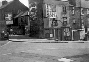
 The bottom of Coombe Street where it joined West Street in 1962.
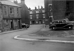
 Mermaid Yard in 1962.
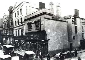
  Milk
Street, to the right, in the 1920's. The street led to Smythen
Street. Photo Dick Passmore
Streets of the West Quarter
Butchers
Row
Coombe Street
Fore Street
George Street
Guinea Street
King Street
Milk Street
New Bridge
Street
Preston Street
Smythen Street
Stepcote Hill
West Street
Small
Courts of the West
Quarter
Albert Place -
Rack Street
Bow Place - Smythen Street
Chudley's Court - Coombe Street
Cobley's Court - Smythen Street
Cottage Court - Coombe Street
George's Square - Stepcote Hill
Helmore's Court - Coombe Street
Johnsons Court - Coombe Street
- in 1911, six families
were reported to be living in this court who shared two toilets and
paid 2s 4d to
2s 7d a week rent.
Lees Terrace - Coombe Street
Paragon Place - South Street
Prospect Place - Rack Street
Shermans Court - West Street
Tabernacle Court - Coombe
Street was still in existence in 1961
Tighe (Teigh) Place - Rack
Street